
The Gaza Strip has sustained widespread destruction as the Israeli military has bombarded the besieged enclave of 2.3 million people for more than two weeks. Even its south, which Israel had declared a safe zone, has not been spared.
Satellite imagery and photographs show entire neighbourhoods have been levelled with many hospitals, schools, places of worship and homes damaged or destroyed by Israeli land, sea and air attacks.
list of 4 items
list 1 of 4
Harrowing video of Gaza residents running for safety from Israeli bombs
list 2 of 4
Photos: South of Gaza Strip pounded by air strikes as civilians seek refuge
list 3 of 4
Second aid convoy enters Gaza as Israel steps up bombardments
list 4 of 4
‘Beautiful solidarity’: Cooking for displaced Palestinians in southern Gaza
end of list
In the following infographic series, Al Jazeera maps out Gaza’s damaged communities and neighbourhoods across the strip’s five governorates: North Gaza, Gaza City, Deir el-Balah, Khan Younis and Rafah.
Gaza’s densely populated neighbourhoods
Bordered by Israel and Egypt on the Mediterranean coast, the Gaza Strip is 365sq km (141sq miles). At only 41km (25 miles) long, it can take less than an hour to drive from Beit Hanoon in the north to Rafah in the south.
The Palestinian enclave has a population of 2.3 million people, including 1.7 million refugees who were ethnically cleansed from areas that now form part of Israel. Most refugees live in or near Gaza’s eight refugee camps.
Since 2007 when Hamas came to power, Israel has maintained strict control over Gaza’s airspace and territorial waters and restricted the movement of goods and people in and out of Gaza.
(Al Jazeera)
North Gaza’s neighbourhoods
(Al Jazeera)
North Gaza extends for 10km (6 miles) and shares the only crossing into Israel through Beit Hanoon, also known as the Erez crossing. North Gaza is home to the Jabalia refugee camp, the largest in the strip.
The 61sq-km (24sq-mile) area is home to 440,000 people and includes the following communities and neighbourhoods: Beit Lahiya, Beit Hanoon, Jabalia refugee camp, Madinat al-Awda and Jabalia al-Balad.
Jabalia refugee camp
The Israeli military has repeatedly hit the Jabalia camp, including on October 9, 12 and 19, killing more than 100 people. The camp houses three United Nations-run schools, which have been converted into shelters for hundreds of displaced families.
This picture taken on October 11, 2023, shows buildings destroyed by Israeli air strikes in the Jabalia refugee camp in North Gaza [Yahya Hassouna / AFP]
Gaza City’s neighbourhoods
(Al Jazeera)
Gaza City is the largest and most populous city within the Gaza Strip with more than 750,000 residents.
Located along Gaza’s Mediterranean coastline are the neighbourhoods of Gaza Harbour, the Shati refugee camp, and Northern and Southern Rimal.
Rimal neighbourhoods
At the heart of the Rimal neighbourhoods is al-Shifa Hospital, the largest medical facility in the Gaza Strip.
Tens of thousands of displaced Palestinians are sheltering at the hospital, where Palestinian doctors are warning of an impending infectious disease outbreak due to overcrowding.
Surrounding the hospital are several UN compounds, including the Relief and Works Agency for Palestine Refugees (UNRWA), the Office of the UN Special Coordinator for the Middle East Peace Process (UNSCO) and the UN Development Programme (UNDP).
Gaza’s top universities – including the Islamic University of Gaza, Al-Azhar University-Gaza and Al-Aqsa University, which are just a few hundred metres apart – are also located in Rimal.
On October 7, Israeli warplanes destroyed the Palestine Tower, a 14-storey residential tower in Rimal, reducing it to rubble. The moment was captured live on camera behind Al Jazeera’s Youmna ElSayed.
An aerial view of destroyed buildings following Israeli attacks in the Rimal neighborhood of Gaza City, October 12, 2023. [Mustafa Hassona / Anadolu Agency]
Shati refugee camp
Israeli attacks have targeted the Shati refugee camp, also known as Beach Camp, several times, terrifying its 90,000 inhabitants living on 0.52sq km (0.2sq miles) of land. On October 9, Israeli strikes destroyed the Yassin Mosque, one of at least 11 mosques that have been destroyed since October 7.
Palestinians inspect the rubble of the Yassin Mosque, destroyed when it was hit by an Israeli air strike in the Shati refugee camp in Gaza City on October 9, 2023 [Adel Hana/AP Photo]
Farther east are the neighbourhoods of Sheikh Radwan, al-Nasr, al-Darraj, al-Tuffah, al-Sabra and Tal al-Hawa.
Tal al-Hawa
On Wednesday, Israeli strikes hit areas near al-Quds Hospital in Tal al-Hawa. More than 8,000 Palestinians had taken refuge at the hospital, which was previously destroyed by Israeli forces in 2009.
Old City
Just north of the Zeitoun neighbourhood is Gaza’s Old City, which is home to several historical sites, including the Great Omari Mosque, known as Gaza’s Great Mosque, and two of Gaza’s churches: St Philip the Evangelist Chapel and St Porphyrius Church.
On Tuesday, a massive blast at al-Ahli Arab Hospital, also in the Old City, killed nearly 500 Palestinians, many of whom were taking shelter from Israeli bombing. The Ministry of Health in Gaza said the blast was caused by an Israeli air raid. Israel has attributed the explosion to a misfired rocket launched by the Palestinian Islamic Jihad (PIJ) armed group. The PIJ has denied the allegation. An Al Jazeera investigation has debunked Israel’s claim.
Two days later, an Israeli air attack killed at least 18 people who were sheltering in the St Porphyrius Church, Gaza’s oldest church, which was built between the 1150s and 1160s. A Palestinian pastor has called the bombing of St Porphyrius, where hundreds of people had taken refuge, a “war crime”.
(Al Jazeera)
Shujaiya
One of the largest neighbourhoods in Gaza City is Shujaiya, which in Arabic means “courage”.
Shujaiya has experienced extensive destruction in past Israeli military offensives. A particularly devastating episode occurred in July 2014 when the densely populated district bore the brunt of heavy tank and artillery shelling that killed 72 people and injured more than 200 in a single day. The incident drew widespread international criticism and condemnation.
The drone footage below, shot in 2014, shows the remains of Shujaiya after Israel’s 50-day-assault.
Al-Zahra
On the outskirts of Gaza City are the neighbourhoods of al-Zahra, al-Mughraqa and Juhor ad-Dik, which have also been hit by Israeli raids.
In al-Zahra, Israeli attacks have levelled at least 10 buildings and left thousands of people either trapped in the rubble or awaiting medical care.
A Palestinian boy walks by buildings destroyed in the Israeli bombardment on al-Zahra on the outskirts of Gaza City on October 20, 2023 [Ali Mahmoud / AP Photo]
Deir el-Balah’s neighbourhoods
(Al Jazeera)
Beginning at Wadi Gaza, a river that divides Gaza roughly into north and south, Deir el-Balah is named after the Monastery of the Date Palm and is one of Gaza’s largest agricultural producers.
Gaza’s only operating power plant is located along the district’s boundary with Gaza City.
Deir el-Balah is also home to four out of Gaza’s eight refugee camps: Nuseirat, al-Bureij, al-Maghazi and Deir el-Balah.
Palestinians look for survivors after the Israeli bombardment of the Gaza Strip in Deir el-Balah, October 22, 2023. [Hatem Moussa / AP Photo]
Nuseirat refugee camp
The Nuseirat camp was established in the aftermath of the 1948 Nakba (“catastrophe” in Arabic) when an estimated 750,000 Palestinians were forced out of their homes by Zionist militias.
Today, the camp is home to 85,000 refugees crammed into an area of 0.68sq km (0.26sq miles).
Israeli air raids have bombed a number of bakeries in Gaza, killing dozens of people and injuring hundreds who were queueing to buy bread, the Palestinian WAFA news agency reported. One such bakery was the Al Nuseirat Bakery, which was destroyed on Wednesday.
Palestinians walk by the rubble of Al Nuseirat Bakery, which was destroyed in an Israeli air strike in Nuseirat refugee camp on October 18, 2023 [Hatem Moussa/AP Photo]
The other neighbourhoods in Deir el-Balah include az-Zawayda, al-Musaddar, Wadi as-Salqa and al-Ma’ani.
Khan Younis’s neighbourhoods
(Al Jazeera)
Khan Younis is Gaza’s largest governorate by area at 108sq km (42sq miles) and is home to 430,000 people. At its centre is the Khan Younis refugee camp, where about 90,000 people live.
The Israeli army has continued striking Khan Younis and other southern areas despite ordering people in Gaza to move south.
Thousands of Palestinians have crowded into squalid tent camps in southern Gaza, many without food or water.
The UNDP has provided tents for Palestinians displaced by the Israeli bombardment of the Gaza Strip in Khan Younis [Ashraf Amra/AP Photo]
Other neighbourhoods in Khan Younis include: al-Qarara, Abasan al-Jadida (as-Saghir), al-Sureij, Bani Suheila, Abasan al-Kabira, Khuza’a, Qa’ al-Qurein, al-Mawasi, Qizan an-Najjar, Qa’ al-Kharaba, al-Fukhkhari and Umm Kameil.
Palestinians inspect the site of Israeli strikes on a house in Khan Younis, October 23, 2023. [Ibraheem Abu Mustafa / Reuters]
Rafah’s neighbourhoods
(Al Jazeera)
Rafah is the southernmost district of Gaza with a population of about 275,000. Rafah is also the name of the crossing with Egypt that is located there.
On Saturday, a convoy of 20 trucks carrying humanitarian aid entered the besieged Gaza Strip through the Rafah crossing.
(Al Jazeera)
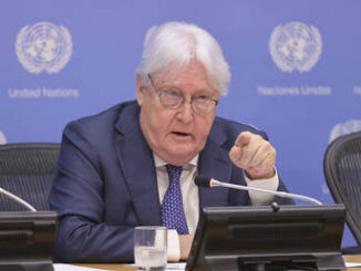
Cindy McCain, the executive director of the World Food Programme, told Al Jazeera that 20 trucks of aid is not enough.
“The situation inside Gaza is dire. Not only is there no food, there is no water, electricity or fuel. And that combination is not only catastrophic but can lead to more starvation and disease as well,” she said. “We’ve got to get more trucks in.”
A second aid convoy entered the besieged territory on Sunday.
A Palestinian kid looks at he buildings destroyed in the Israeli bombardment of the Gaza Strip in Rafah on October 22, 2023. [Hatem Ali / AP Photo]
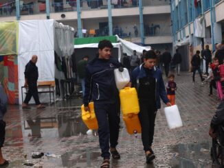
Israel has sealed off the territory, forcing Palestinians to ration food and drink filthy water from wells. Hospitals said they are running low on medicine and fuel for emergency generators during a Gaza-wide blackout.
According to the UN, sanitation facilities, water wells, reservoirs and pumping stations have suffered damage due to incessant air strikes.
(Al Jazeera)
Those who are able to get through the Rafah crossing must then make a six- to eight-hour journey through the Sinai Desert, passing several Egyptian checkpoints on their way to Cairo, about 350km (220 miles) away.
The neighbourhoods in Rafah include: Umm al-Kilab, al-Mawasi, al-Qarya al-Suwydiya, Tel es-Sultan, Rafah refugee camp, al-Bayuk and Shokat as-Sufi.
View the complete map
The Palestinian enclave – home to 2.3 million people – is 365sq km (141sq miles) and is made up of five governorates.